Where can I go road biking in Olympic National Park?
The few roads inside Olympic National Park that allow biking at all tend to be rugged and are more suitable for those on mountain bikes. However, there are areas just outside the park that are wonderfully suited to touring bikes.
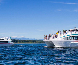
Olympic Discovery Trail
This is a 126-mile lowlands trail that skirts the park but runs between the Olympic Mountains and the Strait of Juan de Fuca. Currently, about 40 miles of the trail is paved from east to west (Blyn to Sequim and Port Angeles) and another 6 miles heading north to lovely Port Townsend is complete as well. Eventually, the trail will go all the way across the peninsula from Port Townsend to La Push on the Pacific Coast.
- Directions: There are numerous access points along the trail. For the paved portion, you can pick up the trail at Sequim Bay State Park on Highway 101, Carrie Blake City Park (Sequim) at Blake and Fir Sts., Railroad Bridge Park on Hendrickson Rd., Robin Hill County Park on Pinnell Rd., Morse Creek Trailhead at Straitview and Highway 101; and at Port Angeles City Pier.
- Distance/Time – You can ride the paved portion – which is 40 miles – in about 3-4 hours, allowing for stops at interesting sites or to enjoy a meal.
- Road Conditions: This is a paved road meant for bikers, hikers, and equestrians. You will, however, find yourself on some low traffic roads or roads with wide shoulders, so use your own judgment when riding with kids.
Highway 101
There are several areas, particularly on the west side of the peninsula, where bike riding on U.S. Highway 101 is plausible. In many regions, the road is lightly traveled and has wide shoulders that make riding safe. For example, the stretch of road from Forks to Kalaloch is often traveled by cyclists and provides amazing views. However, the part of the road along Lake Crescent is a definite no-no! Check with local bike groups or outfitters for suggestions before you head out.
Where can I go mountain biking near Olympic National Park?
The landscape of the Olympic Peninsula provides singletrack rides that put you in the midst of incredible scenery and provide plenty of challenges as well, though there are some rides suitable for beginner to intermediate mountain bikers.
Mount Muller Loop
Woods, wildflowers, and views of some of the Peninsula’s best sites, like Lake Crescent and Mount Olympus, can be enjoyed on this very strenuous single-track ride. On a really good day, you can even spy Vancouver Island and far-away Mount Baker.
- Distance: 13.6 miles
- Elevation Gain: 3,100 feet
- Difficulty: Difficult, with lots of switchbacks and a very hard initial 3-mile-long climb
- Trail Type: Loop, dirt roads
- Trailhead: Travel west from Port Angeles on Highway 101 to 4.7 miles past the Fairholm Store at the end of Lake Crescent, about 30 miles total. Turn right on Forest Service Road 3071. Drive .3 miles to the trailhead parking area.
Lower Big Quilcene Trail
A great second-level trail for those who are a little more than beginners, this one provides excellent views of the Lower Big Quilcene River as well as miles of track through lush forest. But there are some water crossings and you’ll find your share of loose rocks as well.
- Distance: 6.2 miles each way
- Elevation Gain: 1,420 feet
- Difficulty: advanced beginners
- Trail Type: out and back; very smooth but not paved
- Trailhead: Go 1 mile south of the Quilcene Ranger District on Highway 101 to right on Penny Creek Road. Veer left on Big Quilcene River Road (FS 27). In 3.2 miles, go right to stay on narrow FS 27 as FS 2740 continues straight. In another 0.4 mile, turn left on FS 2700-080, just before FS 27 curves up and to the left. Travel .3 mile to the trailhead parking at the end of the road.
Hurricane Ridge
One of the most popular rides in the park yet one of the toughest, this one takes you up the mountain to see some of the most spectacular views in the park. Lots of switchbacks and plenty of traffic make it not for the feint of heart!
- Distance: 34 miles round trip from the park headquarters
- Time: depends on your skill level
- Elevation Gain: 4,300 feet
- Difficulty: Advanced
- Trail: Out and back/paved road
- Trailhead: Take Highway 101 about 17 miles west of Port Angeles to the entrance to the park at Hurricane Ridge Road. This is where your ride can begin.